
With rising sea levels drastically impacting the frequency and magnitude of natural disasters, coastal regions are increasingly at risk. In an exclusive interview with Earth.org, Paul Seaton, Director for Hydrography and Coastal Resilience for Asia Pacific at Fugro discusses the importance of coastal resilience management as a solution to rising sea levels.
_
Among the many repercussions of climate change are significant changes to sea levels and increased natural disasters.
With rising sea levels as a result of rising temperatures, coastal regions are especially vulnerable to the negative impacts of climate change. Changes in global climate becoming more apparent every day across the world, with one explicit example being last year’s devastating floods in Pakistan. The impacts of climate change are quantified by coastal engineers, who state that every 10 centimetres of sea level rise increase the frequency of a given coastal flood by a factor of three.
Over the course of the last three decades, the average annual rise in sea level around the world has been 1.5 millimetres (mm). It was roughly 2.5 mm per year at the start of the 1990s. The rate has climbed to 3.9 mm (0.15 inches) per year over the last ten years.
According to Paul Seaton, Director for Hydrography and Coastal Resilience for Asia Pacific at Fugro – one of the world’s leading geo-data specialist, “much of our existing coastal infrastructure was built several decades ago and has become increasingly susceptible to climate-induced sea level rise and increased storm activity.”
The deciphering of such data, then, is necessary for coastal resilience – the capacity of socioeconomic and natural systems in the coastal environment to cope with disturbances induced by factors such as sea level rise, extreme events, and human impacts by adapting while maintaining their essential functions.
You might also like: What is Causing Sea Level to Rise?
For the facilitation of coastal resilience, geo-data is crucial to mitigating risks from the changing climate, said Seaton. Geo-data provides crucial knowledge for the creation of coastal protection measures, including data on dynamics, vulnerabilities, and any potential problems in the future. At the moment, Seaton explained that the industry has started to look beyond just geo-data as geographic information, focusing on a richer and more comprehensive geospatial overview.”
In order to efficiently implement the integration of geo-data technology and infrastructure, high-resolution topographic and hydrographic data must be combined with complementary data sources, such as imaging, acoustic surveys, meteorology, and physical oceanography, including tide, current, and wave data.
The Need for Geo-Data and Coastal Resilience Management
One of the main challenges posed by climate change is sea level rise projections, and geo-data can specifically tackle this issue. Such projections must be taken into account when developing coastal mapping strategies. The fundamental basis of many communities is laid by coastal infrastructure, which connects people, boosts trade, enhances quality of life, and encourages security and safety.
However, such activities are inhibited due to the majority of our current coastal infrastructure being constructed using antiquated methods at a time when the implications of climate change were not fully anticipated or understood. This indicates that the existing coastal infrastructure may be working above its permissible limits, endangering the security and way of life of the impacted coastal populations.
“The accurate acquisition and implementation of geo- data analysis is paramount to contributing to a safe and liveable world,” said Seaton.
The government of New South Wales (NSW), is a great example of potential geo-data-driven coastal management, as it has repeatedly emphasised that development plans must take sea level rise into account. As he explained , “accurate geo-data acquired at high resolution will act as a baseline for future change, and every subsequent survey or data collection conducted can be used to measure change and help researchers understand the problems that these coastal communities must address.”
In line with this, the NSW government has set out that regions that are predicted to be impacted by sea level rise can be identified as vulnerable zones. In these regions, coastal risks must be taken into account prior to development authorisation and properly zoned in local environmental plans.
Every successive survey or data collection can be used to evaluate change and aid researchers in understanding the issues that these coastal towns must confront. Accurate, high-resolution geo-data will serve as a baseline for future change. Primarily because geo-data takes the effects of climate change into account and may therefore effectively guide the design and development of reliable infrastructure. The accumulation of knowledge in such a manner will result in greater information for better engineering.
Light detection And Ranging (LIDAR), Seaton explained, is a “remote sensing method that uses lasers to measure points on the earth’s surface and can be used to generate highly accurate three-dimensional maps of the Earth.”
As a leading technological development in the advancement of geo-data infrastructure, these sensors can be deployed safely from an aircraft or drone with little to no impact on the environment. They are critical for obtaining crucial topography and bathymetric data for large-scale mapping operations in a quicker and more cost-effective manner than conventional mapping methods.
Current and Potential Success Stories
Globally, the majority of coasts have very little historical coastline data. This is valid not only for isolated Pacific islands like Tuvalu but also for wealthy nations like Australia. Given the high level of scientific community trust that sea levels are rising at an alarming rate , this is very concerning. As a result, the future for so many coastal habitats is bleak; The sea will progressively erode shorelines, taint freshwater sources, and degrade important crops raised by the numerous subsistence farmers living in these areas.
According to Seaton, the best example of how geo-data can be used for coastal resilience is the Tuvalu Coastal Adaptation Programme.
The Tuvalu government started working on decreasing coastal risks and creating a long-term coastal adaptation strategy in 2017, with assistance from the Green Climate Fund and in collaboration with the United Nations Development Programme. The Pacific island had limited access to scientific data despite being on the front lines of climate change and sea level rise for a long time.
“One of the key tasks of the project was to secure the baseline data to highlight the relationship between land elevation and sea level rise, to model future scenarios, and for infrastructure planning,” said Seaton.
With the launch of the Coastal Adaptation Programme, Tuvalu begun collecting precise coastal data using the LIDAR technology. Since then, the data has been used for a wide range of projects, including wave inundation modelling with assistance from the UNDP, shoreline monitoring, the planning and design of reclamation projects, and the construction of coastal defences. Other Pacific countries can now look at Tuvalu and their partners for guidance on how to manage coastal resilience as a result of the project’s success.
“We anticipate LIDAR to become more integrated as the threat posed by sea level rise intensifies and nations take proactive steps to lessen such threats,” said Seaton.
With support from the UNDP, Tuvalu captured data from the edge of their reef and covered the nine atolls, providing a complete map of the nation. This example goes to show that coastal adaptation initiatives to lessen the consequences of climate change and sea level rise are feasible.
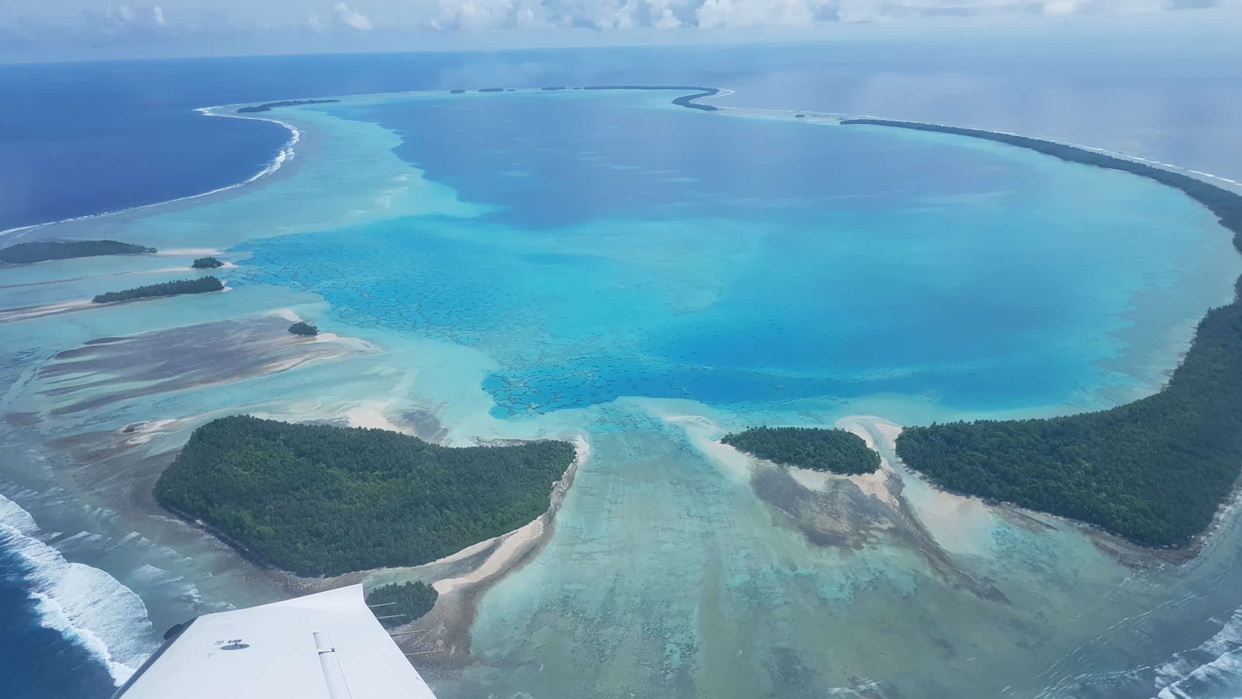
Airborne LIDAR capture over the Palau Islands. Photo: Fugro.
“Tuvalu was the first atoll nation to access Green Climate Fund support with the assistance of the UNDP for a whole of country lidar survey,” said Seaton, adding that this has given the community the best access to knowledge as well as accurate forecasts of its social and environmental implications. Residents of Tuvalu have access to information on the UNDP’s project in the islands, and efforts are well under way in the capital, Funafuti, to ensure that the area is protected from the risk of sea level rise after 2100. A ground-breaking ceremony for the construction of a 780-metre-long and 100-metre-wide reclamation project in Funafuti took place in December 2022.
“This project stands out as a best practise example of the government working with the international community through the UNDP and private sector partners, such as Fugro, to deliver the geo-data needed to make this possible,” said Seaton.
Among the countries that would most benefit from geo-data infrastructure are the Maldives and Kiribati, two low-lying island nations that are particularly vulnerable to sea level rise. to. These nations are particularly vulnerable to flooding and sea level rise since they frequently have small landmasses and low heights. Almost 80% of the Maldives could become uninhabitable by 2050, according to multiple reports from NASA and the US Geological Survey. They are at a disadvantage when it comes to receiving the assistance they require since they frequently lack the resources – both in terms of capability and funding—to drive the prompt adoption of various coastal protection methods.
“Crucially, the cost of not managing our coastal areas is far greater than the costs involved in managing them,” said Seaton.
The expense of gathering baseline data is incorrectly believed to be substantial. This is partly because some parties might not be fully aware of how many different stakeholders can use it, or because people need to have a greater knowledge of what is now possible.
“It can seem intangible for countries and communities not situated on the coast and can also be difficult for people to comprehend over the long term,” he added.
There is an intensified need to make this change and ensure that the communities that are most at risk, like those in small island states worldwide, are prepared immediately.
Limitations of LIDAR
While LIDAR technology can be used in the majority of settings and circumstances, there are a number of things that could hinder its effective operation. The performance of bathymetric LIDAR will vary depending on the surroundings.
“Turbidity, or suspended sediment in the water column, may restrict the depth performance of the laser. Mitigating low to moderate turbidity is achieved by operating a combined LIDAR solution with a higher-powered ’deep’ sensor capable of pushing through some turbidity, which can aid in deeper penetration in challenging environments,” said Seaton.
Physics demands that modern “deep” technology perform at its best. The particles floating in the water column may prevent the laser from penetrating murky water.
“Physics dictates that the optimal depth performance of modern bathymetric LIDAR systems is typically limited to 2 to 3 times this visible,” said Seaton.
The management of activities around rain and river runoff, tide states, and times of intense wind and wave activity are additional strategies for regulating water clarity. These strategies include carefully choosing acquisition times when environmental conditions are optimal. Successful LIDAR surveys largely depend on the ability of the survey team, flexibility in operations, and knowledge of the project region.
As Seaton explained, “for topographic areas, the presence of dense vegetation could hinder the acquisition of accurate elevation data in coastal areas, limiting the ability to capture detailed information about the underlying terrain.”
LIDAR is susceptible to atmospheric conditions like many other sensors, and the quality and accuracy of the data collected can be impacted by fog or severe rain. Planning the region for data collection is another important factor.
Costs are incurred when teams and assets are deployed to collect data using these sensors. To cut costs, remote sensing techniques are frequently more effective when used to survey large areas. The more expensive data gathering expenses for tiny areas may limit the kind of sensors that can be employed. This may cause some decision-makers to rely on older methods of data collection.
“There is a steady growth in the demand for better quality geo-data,” Seaton explained.
LIDAR solutions have been deployed for various public projects in markets such as Australia, France, the US, the UK, and Canada, among many others, for a number of years.”
“As the threat of rising sea levels becomes more pronounced and countries actively take measures to mitigate such threats, we expect LIDAR to become increasingly integrated.”
“One way around this is to bring multiple stakeholders together to share the cost and ensure maximum use of the data collected,” said Seaton.
He also argued that any cost analysis for the use of LIDAR should evaluate how well the technology can meet demands and goals of the larger community that will benefit from the data produced.
Asymmetric Beneficence of Developed Countries
“In simple terms, those communities that did the least to contribute to the climate crisis are the most at risk,” said Seaton.
Several strategies will need to be used, including technology transfers and knowledge exchange, community empowerment, international cooperation, and financial support, to achieve climate equality and close the technological gap in coastal protection.
According to Seaton, “this will better position developing countries to narrow the inequality gap and better protect vulnerable communities from being further disadvantaged, resulting in increasing equality and long-term resilience in the face of climate change.”
Those who require access to the enabling technology and services for geo-data can get the answers they need through international cooperation that includes independent geo-data suppliers. With regard to data, there is still a need for technological transfers and knowledge sharing, especially in areas like the development of new, potent modelling and visualisation tools that help users comprehend and interpret the data. Advanced geo-data technology can predict the impact and better prepare thanks to models.
“The returns on investment for coastal resilience projects depend on the location and the projects. But experience has demonstrated that the return for every dollar invested in preparation and mitigation can save anything from 4 to 11 times the cost of recovery efforts.”
Despite the obvious benefit, many emerging coastal communities will need financial support and international cooperation to overcome these problems.
Cross-Sectoral Collaboration: The Solution
Understanding our seas and providing the appropriate information to people involved in coastal protection planning will depend heavily on collaboration.
Fugro has been leading the commercial sector in support of the Nippon Foundation-GEBCO Seabed 2030 Project because it understands the significance of a fully mapped ocean to climate change and coastal resilience. It was predicted that only 6% of the world’s seas had been mapped using contemporary standards when the project was started in 2017. We are now closer to 25% thanks to international cooperation between countries and business, but there is still a lot of work to be done. Currently, attempts are being made to involve the corporate sector in order to unlock its locked-up ocean geo-data and knowledge.
Collaboration among community stakeholders to produce appropriate datasets for coastal zone management is extremely valuable at the local level. Data products can map the topographic coastline, the accompanying seabed, tide, current, and wave data, as well as the texture of the seabed and marine flora, all in a single survey. These can be used to create high-resolution topographic mapping goods necessary for estimating erosion and the condition of infrastructure, as well as high-resolution seabed mapping products for studying sediment flow and mapping benthic habitat and other products for coastal engineering.
Some stakeholders might only need a portion of these solutions, but by working together, significantly more research can be done while just slightly increasing the amount of time needed to map the area and provide the necessary geo-data.
You might also like: Sea Level Rise Projections: 10 Cities at Risk of Flooding